
The town name originated from Turk tribal name “kuva” known among the Kyrgyz and Uzbek peoples. The exact data when the town was founded is unknown but scients-archeologists conducting the study of the ancient city refer the data to the III century BC.
According to the study based on the Arab written sources of the VII-Х centuries, the medieval city was known as Kuba city. It was situated along the ancient caravan road which connected the Fergana Valley with Kashgar. Once Kuba ranked the second in the region after the ancient capital of the Ferghana Valley – Ahsiket, but late in the XIII century the city was destroyed by the Mongolian invasion.
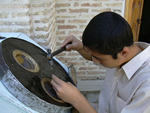
The ancient city consisted of three parts: a citadel, shakhristan (inner part of the city) and rabid (residential part of the city). In the Middle Ages Kuva played an important economic and political role in the Fergana valley which at that time had developed handicrafts especially such as pottery and gold-work, metal treatment.
The first archeological studies of the city started as back as 50-s of the XX century during construction of the Big Fergana Canal, but the expedition of 1956-57 was the largest success in findings.
автор: русский гид Doston Shukurov
написать гиду

 ваше сообщение отправлено